First ascent and biodiversity survey in a little-explored mountainous region of Sarawak (Borneo) – an expedition report
In the spring of 2024, I was commissioned to join members of a Penan community in reaching an area in the interior of Sarawak that has been scarcely documented scientifically to date. In addition to recording the fauna, the main objective was to make what is believed to be the first ascent of an unclimbed peak located there. For reasons of species and cultural protection, no exact locations or personal names are mentioned in this report.
Methodology and ethics
Navigation: Combination of local paths, Penan route knowledge, and GPS-supported precision orientation in the summit zone.
Provision logistics: Decentralized rice caches along planned return routes; minimization of loads while maintaining redundancy.
Biodiversity work: Non-invasive photo and video recording, primarily at night; no use of attractants or traps.
Cultural preservation: All activities were carried out in close consultation with the Penan family. No publication of identifiable location and personal data to protect habitats and people from unwanted attention, including wildlife smuggling.


The Penan are one of the indigenous peoples of Borneo. Many families now live a sedentary or semi-nomadic lifestyle, but some groups continue to practice a mobile lifestyle as hunters and gatherers. Traditionally, the Penan hunt with blowpipes (“sumpit”) and poisoned arrows; the arrow poison (“tajem”) used is extracted from plant latex. A central cultural value is the principle of molong – resources are only used in such a way that there is always enough left for the future.
At the same time, even remote communities are not completely free from outside influences: small solar panels, batteries, simple LED lights, and plastic objects have found their way into their lives in recent years. In the late 1980s, Penan in several regions of Sarawak temporarily blocked logging roads to protect their forests – a conflict whose ecological aftermath is still visible today.
Our starting point was a small, simple settlement near an old logging road that had previously been blocked by the Penan. From there, we marched deeper into the forest for days on end, following traditional paths. The Penan carry their belongings on their backs; along the route, they maintain temporary camps called “lamin” (“a place to spend the night”).
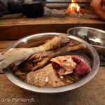
The camps offered little comfort, but significantly more protection than a hammock in the open rainforest. Constantly burning fires kept sand flies away; at the same time, the ash required constant care to protect my camera equipment. For the three-month expedition, we set up rice depots (caches) at points we were sure to pass again. This allowed us to reduce the base weight. I rarely ate meat; my main food consisted of rice and chili oil that I had brought with me. The group used rest days for hunting, as agriculture is not traditionally part of the Penan’s subsistence repertoire.


Daily distances of 15–20 km cross-country are physically and mentally demanding in the rainforest, especially with luggage. We crossed rivers, traversed valleys, and covered up to 1,800 meters of elevation per day.
The Penan are accustomed to this terrain and often move astonishingly fast barefoot. Despite my own experience, the combination of a ~40 kg backpack load and terrain ditches sometimes pushed me to my limits; after two months, however, I was in much better physical condition.
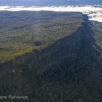
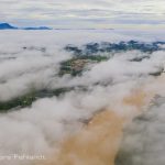
We crossed former logging areas several times. Erosion and landslides marked the scars of overused slopes. Even 15 years after the last logging, the root mat that stabilizes the soil was missing in many places; heavy rain then easily washes the open soil into the valley. With Borneo’s high rainfall, young trees are slow to fill such gaps – with consequences for water turbidity, nutrient balance, and habitat continuity.


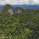
After about two months, we reached the foot of our target mountain and set up a lamin as a high camp at approx. 1,500 m above sea level. Persistent rain initially forced us to remain inactive for four days – a testing trial of patience in damp clothing and nighttime cold for tropical conditions.
The subsequent attempt to ascend immediately revealed the objective difficulties: steep flanks, thick moss cushions, a tangle of roots and rock steps. A total of six attempts were necessary to find a safe route. The Penan were unfamiliar with the path – there is neither big wildlife nor a lot of edible plants in any significant density; there is therefore no incentive for local use to seek out these heights.


At a supposed pre-summit, GPS data corrected our location; the main summit was still just under 2 km away as the crow flies. An experienced Penan took the lead, while I continuously checked the elevation profile and direction. After another ~4 hours, we reached the highest point. A short drone recording was used for topographical classification.
From the camp at the foothill to the summit, the distance covered was ~10 km and the elevation gain was >2,000 meters. The time spent at the summit was short: wind, residual moisture, and the approaching dusk left only time for a quick snack—a few cookies for the team—and a moment of quiet reflection. The Penan rarely show open emotions, but on this day, their quiet pride was palpable. The descent took ~6 hours; we reached Lamin long after dark.


Biodiversity findings
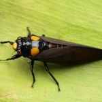
Already on the approach, I was able to photograph several rare species; in several cases, these were first records for the area. After the ascent, I used the newly established trail for two more weeks for nighttime walks into the higher montane zone, mostly to just below the summit. In the process, I documented organisms that had not previously been reported to science in this region, as well as sightings of taxa that are considered endemic to other mountains in the literature but also occur here. A taxonomic evaluation and independent confirmation are prerequisites for this; therefore, species names are not given here.
The expedition was only possible because traditional knowledge – for example, about safe river crossings, wildlife trails, weather changes, or suitable locations for camps – was combined with modern technology (GPS, drones, LED lights). The Penan embody a remarkable ecological literacy of their forest; at the same time, solar panels, batteries, and lightweight synthetic materials demonstrate a pragmatic approach to innovation, provided that it increases rather than decreases mobility and autonomy.
Conclusion
The venture demonstrates that even in the 21st century, there are still blank spots in scientific mapping in Sarawak. The presumed first ascent and the associated development of a safe route will enable systematic surveys of the montane fauna and flora of this massif in the future. The long-term consequences of earlier deforestation are also visible – a reminder that areas of high biodiversity must not only be discovered, but also permanently protected.
Note: For reasons of species and cultural protection, no exact locations, personal names, or animal photos have been included. Upon request, I can provide a more detailed internal version with methodological details for official or academic submission, while maintaining confidentiality.
Impressions


related posts: